SMILE Team Develop High-Resolution Global Dataset for Material Stocks
SMILE Team has led the development of a groundbreaking global dataset that maps anthropogenic material stocks at unprecedented resolution. The research, published in Scientific Data (Nature), provides the first comprehensive view of steel, aluminum, and cement stocks worldwide at a 500×500-meter grid resolution from 2000 to 2019.
A New Window into Urban Material Accumulation
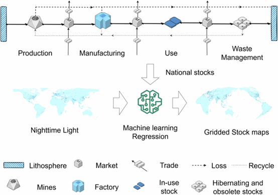
The SDU team, including Associate Professor Wu Chen, Dr. Kun Sun, from the Department of Green Technology, collaborated with Professor Bailang Yu (East China Normal University) and Professor Gang Liu (Peking University) to create this high-resolution dataset. The work integrates reconciled nighttime light imagery with national material stock data, overcoming critical limitations in previous satellite-based approaches. “Traditional approaches faced a trade-off between research scope and spatial resolution,” explains the research team. “Our dataset bridges this gap by combining top-down material flow analysis with advanced nighttime light data processing.”
Key Innovation
The dataset addresses two major challenges in previous global material stock maps:
- Enhanced resolution: Improves from 1km to 500m grid resolution, revealing finer spatial details within cities.
-
Improved accuracy: Mitigates saturation and blooming effects in nighttime light data that compromised earlier estimates.
The methodology employs country-specific regression models that establish relationships between average material stocks and light intensity per unit area, accounting for distinct developmental patterns across 119 nations with known stock data.
Global Implications
The comprehensive dataset comprises 60 TIFF files documenting three key construction materials over two decades. Validation studies demonstrate over 80% of city-level estimates fall within -20% to 40% of literature-reported values, confirming reasonable consistency despite geographic variations.
The research reveals:
- Global anthropogenic stocks continue to accumulate, with significant spatial heterogeneity between and within urban areas.
- Urban core areas show higher stock densities previously obscured by satellite data limitations.
- Distribution patterns highlight disparities in material accumulation across different development stages.
Applications for Sustainability
This spatially explicit dataset serves as an essential resource for:
- Urban mining: Identifying recyclable material reservoirs for circular economy strategies.
- Climate action: Carbon accounting and decarbonization planning through embodied emissions assessment.
- Urban planning: Supporting strategic infrastructure development and waste management policies.
- Policy development: Enabling sub-city level analysis crucial for localized sustainability initiatives.
The dataset is supported by the Independent Research Fund Denmark (iBuildGreen project) and China’s National Natural Science Foundation, highlighting strong international collaboration in addressing global resource challenges.
Access the dataset
Read the full paper
Scientific Data is a peer-reviewed, open-access journal for descriptions of datasets published by Nature Portfolio. The dataset will be maintained and updated every 3-5 years to ensure continued relevance for global sustainability research.